Playground · Signals / Hardware / Visualization
Flight Tracker
v1.0
A local receiver turns aircraft broadcasts over Western Washington into a live, 10-foot-friendly view of the airspace.
Semi-live
Live from the listening station.
When the receiver is on air, this read-only public mirror updates from the local ADS-B installation about every ten seconds. The listening-station location shown here is deliberately approximate.
Invisible World / Traffic
What it does
Makes the aircraft overhead visible.
Flight Tracker listens to 1090 MHz ADS-B broadcasts and plots aircraft on a live map of the Puget Sound region. The experience is built for a television rather than a desk: large aircraft silhouettes, altitude masts, bold labels and a rotating hero treatment make the traffic readable from across the room.
It is intentionally local-first. The receiver, decoder, route enrichment and interface run as a small appliance on the home network.
Aircraft position, speed, heading and barometric altitude update from locally received ADS-B messages.
Normalized vertical masts make relative altitude immediately visible. A mast-top indicator shows climbing, level flight or descent.
Ghosted recent positions and trails make direction and movement visible without turning the map into a dense tracking interface.
Every few seconds one aircraft is promoted into a large, readable card with callsign, altitude, speed, broad aircraft class and a plausible origin-to-destination route.
A scoreboard overlay tracks highest altitude, fastest aircraft, longest observed aircraft and total aircraft seen during the current session.
If receiver data stops, the interface detects staleness, fades stale traffic, clears frozen aircraft and recovers automatically when fresh data returns.
Hardware
A small radio appliance.
Software stack
Radio in. Browser out.
airspy_adsb receives and forwards 1090 MHz ADS-B messages.readsb turns those messages into aircraft state and continuously writes local JSON.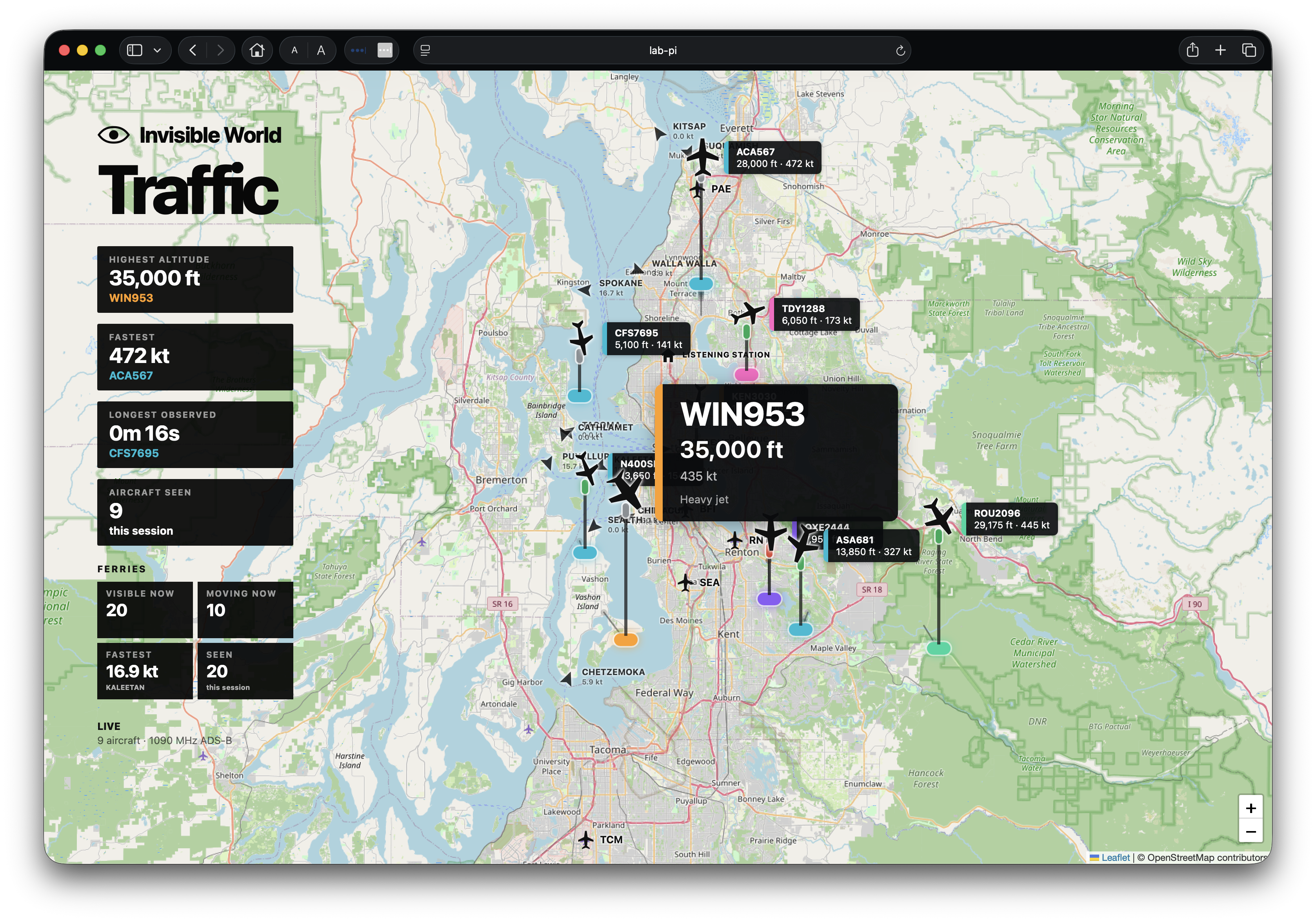
Design notes
Designed to be watched.
The map keeps its geographic detail because the labels are part of the experience: it is satisfying to notice exactly which town an aircraft is crossing. Aircraft markers are deliberately larger than a conventional flight-tracking UI because the display is meant to work at television distance.
Local truth first. Position, altitude, heading and speed come from the receiver. External route information is treated as optional enrichment and hidden when it looks implausible.
Part of Invisible World. Flight Tracker is the first mature layer in a broader experiment about making signals and systems that already surround us visible.
Do it yourself
Build one for roughly $350.
You do not need specialized aviation hardware to make a version of this. The core system is a Raspberry Pi, an SDR receiver and a 1090 MHz antenna. Most of the software is open source.
Approximate U.S. street prices in 2026. Antenna mounting, long coax runs, lightning protection and a display can add to the total. If you already have a Pi, display or compatible SDR, the cost drops quickly.